
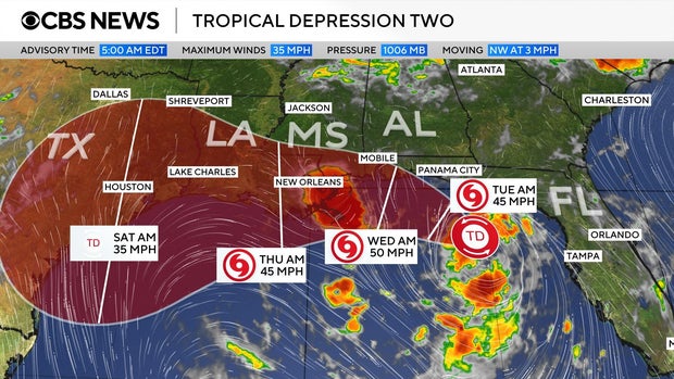
On Monday, Tropical Storm Bertha formed, posing a threat to the Gulf Coast with significant rainfall. It is the second named storm of the 2026 Atlantic hurricane season. The National Weather Service reported that the storm was situated south of the Florida Panhandle with maximum sustained winds of 40 mph, moving west-northwest at roughly 3 mph.
Forecast and Path
A map detailing the storm’s path shows it moving along the Gulf Coast. Initially, it will travel west from the Florida Panhandle, reaching the New Orleans area before advancing to eastern Texas later in the week. Initially recognized as Tropical Depression Two, it escalated into Tropical Storm Bertha.
The weather service indicated that a slow northwest motion is expected through the night, with a subsequent turn towards the west-northwest or west. The depression is forecasted to move near or along the northern Gulf coast in the coming days.
Warnings and Watches
A Tropical Storm Watch has been issued from the Ochlockonee River in Florida to the Jefferson/Plaquemines Parish border in Louisiana. Additionally, a Storm Surge Watch is in effect from the Alabama/Florida border to the mouth of the Mississippi River.
Weather Impact and Precautions
Forecasts predict rainfall reaching up to 8 inches in parts of the region. Rainfall is expected throughout the week along the Gulf Coast and nearby inland areas from western Florida to the Texas coast, also affecting regions in Alabama, Mississippi, and Louisiana. This significant precipitation could result in flash flooding.
The system may also cause storm surges, potentially raising water levels by as much as 4 feet in select areas along the Gulf Coast.
Tropical Storm Bertha’s emergence comes weeks after Tropical Storm Arthur, which was the first named storm of the season and made landfall in June along the Texas Gulf Coast.