
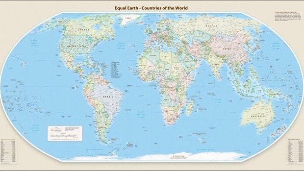
The United Nations General Assembly endorsed a new world map to represent Africa more accurately in its larger size. This decision is the result of efforts by African countries and advocacy groups to present a more truthful depiction of continental proportions. The resolution was sponsored by Togo and supported by African Union members.
During the vote, 164 member states supported the resolution, with the U.S. being the sole opposition. Serbia, Estonia, Georgia, Lithuania, Moldova, and Ukraine abstained from voting. The aim is to encourage global entities to adopt the Equal Earth projection, which geographers believe provides a more accurate representation than the longstanding Mercator map.
The Mercator map, widely used since the 16th century, distorts size, making Greenland and Africa appear similar. In contrast, the Equal Earth projection showcases Africa as 14 times larger than Greenland. Though the resolution does not ban the Mercator map, it advocates for the Equal Earth projection.
Togo’s Foreign Minister Robert Dussey remarked, “Maps shape our understanding of the world. They guide education, nourish the imagination, and influence collective perceptions.”
Africa No Filter, a leading campaigner for the new map, welcomed the resolution, aiming for accurate maps in educational materials, media, and digital platforms. French Foreign Minister Jean-Noël Barrot stated on X that correcting map distortions is an act of truth.
The Mercator map, designed by Gerardus Mercator, aided European navigators but distorted landmasses, enlarging regions like North America and Greenland while shrinking Africa and South America. The 2018 Equal Earth projection adjusts to the Earth’s curvature for true proportions.
Syracuse University geography professor Mark Monmonier noted the Mercator map is only beneficial for navigation, emphasizing the need for more accurate applications outside of that field.