
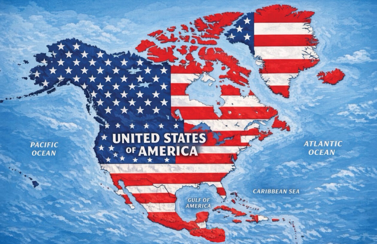
On Monday, President Donald Trump shared an AI-generated map on Truth Social depicting a massively expanded United States, covering most of North America. The map superimposes the U.S. flag over Canada, Mexico, Greenland, Cuba, and other regional territories. The president provided no text to clarify the post, and the White House has not confirmed the map as indicative of any formal policy.
Geographically, the map covers the North American continent, which generally includes 23 sovereign nations. It also encompasses Greenland, an autonomous region of Denmark, and various Caribbean countries and territories.
The map aligns with Trump’s recent statements suggesting changes to regional political boundaries. Previously, he mentioned Canada could become the 51st state and has aimed to bring Greenland under U.S. control. Furthermore, his administration has heightened diplomatic tensions with Mexico and Cuba.
Newsweek contacted the White House for more information about the map’s implications.
International Reactions
Some depicted countries have already rejected Trump’s territorial ambitions, although they have not specifically commented on Monday’s map.
Canadian Prime Minister Mark Carney has repeatedly dismissed the idea of joining the U.S. During a May meeting, Carney emphasized that Canada is not for sale, a sentiment Trump countered by saying, “Never say never.”
Mexico’s President Claudia Sheinbaum firmly defended national sovereignty. On Monday, she took to X to affirm Mexico’s independence, stating, “Mexico is neither a colony nor a protectorate. We are proudly free, independent, and sovereign.”
Cuba also resisted Trump’s policies. Foreign Minister Bruno Rodríguez accused the U.S. of enforcing a “collective punishment” through an energy blockade and intensified sanctions, causing significant power outages.
Political Commentary
On Sunday, Trump shared other AI-generated images, such as New Mexico labeled “New America” and declarations like “The Moon Is Ours.” Earlier this year, he signed an executive order to rename the Gulf of Mexico as the “Gulf of America.” These changes only apply to U.S. federal government references and lack international recognition.
Trump further escalated tensions by declaring Lake Ontario as “Lake America” amid a trade dispute with Canada.
Craig Agranoff, a political professor at Florida Atlantic University, explained the imagery more closely resembles messaging than policy. Agranoff noted that using maps without text is classic provocation.
“Countries should not treat it as empty noise,” Agranoff advised. Highlighting that when a president overlays the American flag on other nations, silence can imply acceptance, thus complicating diplomacy, trade, and security cooperation.
List of Countries and Territories in Trump’s Map
- Canada
- United States
- Greenland—autonomous territory within Denmark
- Iceland
- Mexico
- Belize
- Guatemala
- Honduras
- El Salvador
- Nicaragua
- Cuba
- Jamaica
- Haiti
- Dominican Republic
- Bahamas
- Puerto Rico—U.S. territory
- Cayman Islands—British Overseas Territory
- Antigua and Barbuda
- Saint Kitts and Nevis
- Dominica
- Saint Lucia
- Barbados
- Saint Vincent and the Grenadines
- Turks and Caicos Islands—British Overseas Territory
- British Virgin Islands—British Overseas Territory
- U.S. Virgin Islands—U.S. territory
- Saint-Martin—French overseas collectivity
- Sint Maarten—constituent country within the Kingdom of the Netherlands
- Anguilla—British Overseas Territory
- Saint Barthélemy—French overseas collectivity
- Montserrat—British Overseas Territory
- Guadeloupe—French overseas department and region
- Martinique—French territorial collectivity
- Grenada