
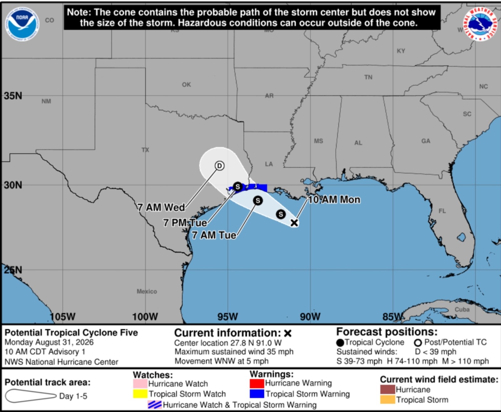
A tropical rainstorm moving across the northern Gulf Coast is set to bring hefty rainfall, potential flash flooding, and travel delays to parts of Texas and Louisiana. Forecasters caution that some areas may receive several inches of rain in short periods. While the storm isn’t expected to generate strong winds, the primary concern remains the heavy rain as it nears the coast.
The National Hurricane Center (NHC) has begun issuing advisories on Potential Tropical Cyclone Five, located in the northwestern Gulf. This system currently has sustained winds of 35 miles per hour. Tropical storm warnings are in place for sections of the upper Texas and southwestern Louisiana coast as the system advances west-northwest at about 5 mph.
Forecasters suggest the disturbance may strengthen before reaching land. AccuWeather indicates the storm might briefly organize into a tropical depression or tropical storm as it approaches the coast on Tuesday. If it achieves tropical-storm strength, the assigned name would be Edouard.
The heaviest rainfall is predicted first along coastal Louisiana, then moving into southeastern Texas, impacting areas including the Houston metropolitan region.
The system is expected to bring rainfall totals of 3 to 6 inches, with maximum amounts reaching 9 inches along the Upper Texas Coast advancing inland through east-central Texas, and 2 to 3 inches for Southwest Louisiana.
Widespread rainfall of 1 to 2 inches is forecast along the Louisiana coast and into eastern Texas this week. A band of 2 to 4 inches is likely around Houston and southeastern Texas, with some spots seeing much higher totals due to persistent thunderstorms. AccuWeather’s Local StormMax forecast suggests isolated areas could receive up to 12 inches of rain by Wednesday.
Showers and storms are expected to pick up in Louisiana on Monday before expanding into coastal Texas by Monday night and Tuesday. Houston and nearby areas are projected to face extended periods of rain from late Monday into Tuesday, increasing the likelihood of flooded roads and travel disruptions during peak commuting times.
Satellite images from windy.com illustrate the storm’s progression toward the coast late Monday morning. Even if rainfall doesn’t reach peak levels in some areas, intense downpours may overwhelm drainage systems, resulting in standing water in low-lying zones. Authorities regularly advise against driving on flooded roads due to unpredictable water depth and possible road damage beneath floodwaters.
Wind impacts are expected to be minimal. The system might bring isolated gusty winds near the coast and in stronger storms, along with rough seas and risky conditions for small vessels in the northern Gulf. Widespread destructive winds or severe coastal flooding are not anticipated at this time.
Once inland over southeastern Texas, the storm is forecast to weaken quickly and lose its structure. Tropical moisture will likely persist over the Gulf Coast throughout the week, fostering additional rain and thunderstorms from Texas to Florida. This suggests localized flooding concerns may linger even after the system dissipates.
For further details, contact Newsweek editor Anthony Murray.