
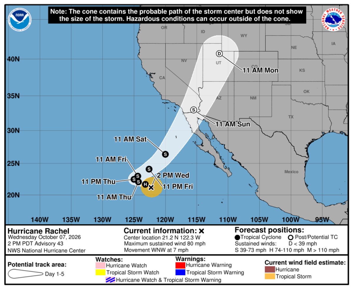
Current Impact of Hurricane Rachel
Hurricane Rachel, now swirling in the Pacific Ocean, is poised to increase the risk of coastal flooding in Southern California. This could lead to significant rainfall over the weekend and into early next week. Forecasters caution that south-facing beaches, including Long Beach Peninsula, Catalina Island, and areas from Malibu to Ventura, face elevated flooding risks due to Rachel’s influence.
The active hurricane season, intensified by El Niño, adds complexity to current weather patterns.
Influence of El Niño and Kelvin Wave
El Niño is contributing significantly to flood risks with the arrival of a Kelvin wave that raises sea levels by 6 to 12 inches. Higher sea levels amplify the threat along California’s coastline. Ryan Kittell, a meteorologist from the National Weather Service in Oxnard, expects the peak flood risk on Sunday.
“Significant beach erosion is expected, especially Sunday,” Kittell stated. Vulnerable areas, previously impacted by flooding, remain exposed.
Tidal Changes and Rain Predictions
Elevated sea levels, intensified by warm ocean temperatures from El Niño, will see tides rise 1 to 1.5 feet above normal levels. Potential damage may arise, similar to that experienced during Labor Day weekend with Hurricane Marie.
Forecasters now predict that this El Niño could be the strongest recorded since 1950.
Current projections show that Hurricane Rachel, a Category 1 storm on Wednesday, will weaken as it nears Southern California. Forecasts predict a northwest movement, followed by a sharper turn due to interacting low-pressure systems from the north. These systems will merge with Rachel’s residual moisture, forming a new system over the area.
Rain is expected between Sunday night and Monday. Kittell highlights a 70% to 90% probability of rain between Saturday and Tuesday in L.A. and Ventura counties, with peak chances Sunday night through Monday night. Those participating in the 2XU Long Beach Marathon face a 40% to 50% chance of rain. The expected rainfall is modest, ranging from one-quarter to three-quarters of an inch, with increased amounts in mountainous areas.
Storm Conditions and Wind Forecast
Southern areas, including San Diego County, Orange County, and the Inland Empire, may see enhanced rain probabilities from Sunday to Tuesday. The weather service in Monterey warns of potential inundation in low-lying areas near shorelines in the San Francisco Bay Area.
Strong winds are anticipated, with speeds between 20 to 35 mph, making Sunday the windiest day according to Kittell.
“Strong rip currents and dangerous waves will increase drowning risks at beaches,” warns Kittell.
These risks accompany the coastal flooding threat due to high tides and the Kelvin wave.
Understanding Kelvin Waves
Driven by El Niño, Kelvin waves elevate water temperatures and sea levels. These conditions, combined with storm swells and high tides, exacerbate coastal flooding risks.
Kelvin waves follow coastal boundaries in the Northern Hemisphere, according to Michael Jacox from NOAA’s Fisheries’ Ecosystem Science Division. The latest Kelvin wave, possibly north of San Francisco, maintains elevated sea levels, with data indicating another El Niño-related wave en route from the tropics.
Kevin waves are increasingly recognized as hazards due to rising sea levels from climate change. The California coast’s sea level has increased by about one foot over the last 125 years.
El Niño’s Influence and Temperature Records
NOAA’s Climate Prediction Center reports an 83% chance of a record-breaking El Niño, reflecting recent warming trends. El Niño affects weather globally every two to seven years, leading to significant rainfall and coastal erosion.
Southern California saw major rainfall during the strongest El Niños in 1982-83 and 1997-98, causing widespread devastation.
Currently, Pacific Ocean temperatures exceed historical records by 18 degrees.
The Climate Prediction Center indicates substantial impacts from this event are likely, though not guaranteed.
Heat Wave and Weather Advisory
Southern California’s high heat, with temperatures reaching 95 to 105 degrees, is set to decrease by Sunday or Monday. The heat persists, with highs forecasted at 101 in Paso Robles and 100 in Woodland Hills. An extreme heat warning is in effect through Thursday evening.
“Stay in air-conditioned spaces during peak heat hours,” the weather service advises.
Kittell signals possible elevated heat conditions toward the end of the next week, albeit not as extreme.