Communities in the central and eastern United States are experiencing a severe heat wave, projected to be both record-breaking and potentially dangerous. This heat wave intensifies with high humidity, which will escalate as the July Fourth holiday approaches.
According to Nexstar Chief Meteorologist Brian James, the heat index, which combines temperature and humidity to indicate perceived heat, may reach between 105 and 115°F. By Tuesday, cities like Chicago and Minneapolis had already experienced heat indices soaring past 100°F.
Expected Temperature Spikes
The forecast predicts several days where temperatures, not heat indices, could surpass 100°F. Such conditions will affect areas from the lower Great Lakes to the mid-Atlantic and Mississippi and Ohio River valleys, with the possibility of setting new high temperature records.
National Weather Service meteorologist Bryan Putnam noted that record highs might occur in regions spanning from the lower Great Lakes to New England later this week. This temperature surge coincides with major events like World Cup matches and the country’s 250th anniversary celebrations.
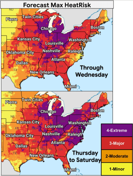
East Coast cities like New York, Philadelphia, Washington, and Baltimore, along with Midwestern cities including Chicago and Indianapolis, are among those expected to feel the heat. Southern cities such as Dallas, Little Rock, and Memphis will also experience high temperatures.
Cities Approaching Record Temperatures
| Wednesday | Expected Temperature | Previous Record/Year |
|---|---|---|
| Binghamton, New York (BGM) | 91°F | 90°F (2018) |
| Washington Dulles, Virginia (IAD) | 100°F | 96°F (2012) |
| Thursday | Expected Temperature | Previous Record/Year |
| Albany, New York (ALB) | 99°F | 98°F (1966) |
| Boston, Massachusetts (BOS) | 101°F | 98°F (1963) |
| Friday | Expected Temperature | Previous Record/Year |
| Bridgeport, Connecticut (BDR) | 100°F | 99°F (1966) |
| Baltimore Downtown, Maryland (DMH) | 104°F | 102°F (1997) |
| Saturday | Expected Temperature | Previous Record/Year |
| Baltimore/Washington International, Maryland (BWI) | 101°F | 100°F (2002) |
| Richmond, Virginia (RIC) | 102°F | 100°F (2002) |
Understanding the Heat Dome Effect
A heat dome currently affects the region, characterized as a high-pressure system that leads air to sink and trap warmth. According to the NOAA, this system results in little or no cloud formation or rain, leading to the persistent accumulation of surface heat that defines a heat wave.
This high-pressure system also diverts potential storms, reducing the likelihood of cooling summer thunderstorms.
Precautionary Measures
The National Weather Service suggests checking on vulnerable people such as young children, older adults, and individuals with chronic health issues. Experts advise staying hydrated, taking breaks in the shade during outdoor activities, limiting strenuous efforts outdoors, and never leaving children or pets in unattended vehicles.
The Associated Press contributed additional information to this report.