
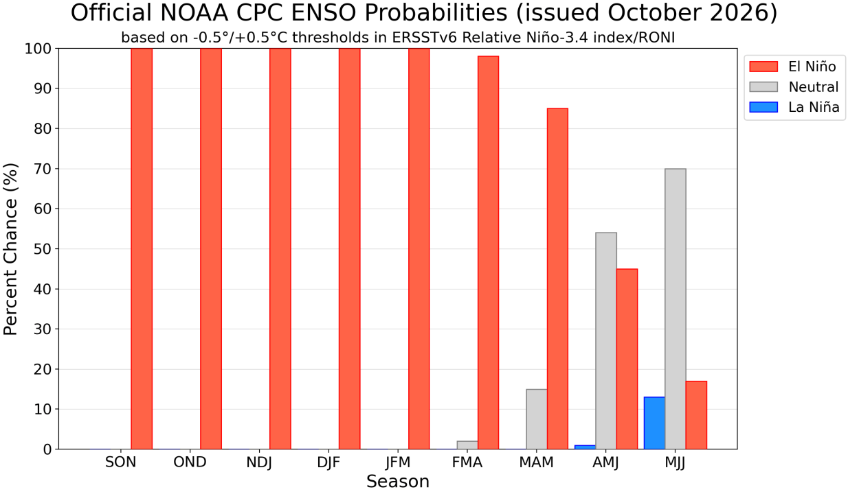
Weather experts are observing an intensifying El Niño, projected to be the strongest in documented history. The latest updates from NOAA’s Climate Prediction Center reveal that El Niño has “strengthened further last month,” with predictions of a strong-to-very strong phase from January to March. Various models suggest that El Niño’s strength could continue growing through year’s end.
The Climate Prediction Center’s latest guidance highlights the heightened chance of a historic climate event, possibly surpassing the intensity of El Niño occurrences since 1950. Though effects typical of El Niño are more probable with such intensity, they are not guaranteed.
Late the previous month, Azhar Ehsan, a climate scientist at Columbia University, shared a chart with the media illustrating a “100% to 99%” probability of El Niño persisting into the spring. “I wrote near-certain but it’s 100%,” he emphasized.
The NOAA Climate Prediction Center concurs, assuring that El Niño will persist for about six more months. The prospect of a transition to a La Niña pattern is also indicated, represented by the blue bar in their forecasts. Their visualization shows the likelihood of El Niño, marked with a red bar, in successive three-month intervals.
The World Meteorological Organization’s Global Seasonal Climate Update forecasts that El Niño will peak in December, expecting sea-surface temperatures to rise to record levels. As WMO Secretary-General Celeste Saulo explained at the Global Heat Forum, El Niño doesn’t add new warmth to the planet but releases stored oceanic heat, often leading to some of the hottest recorded years.
This enduring El Niño may significantly impact weather patterns in the coming months. According to Brian James, Nexstar’s chief meteorologist, the differences will manifest distinctly between the northern and southern US. Generally, northern areas might experience drier and warmer conditions, while southern regions could face cooler and wetter climates.
Climate scientist Daniel Swain from the California Institute for Water Resources expressed on social media his concerns over this unprecedented event within our rapidly warming climate. California has preemptively declared a state of emergency, with preparations underway in Los Angeles.
Ehsan noted at a September briefing that current atmospheric patterns mirror those of 1997, a year noted for a powerful El Niño event. Back then, records fell under unusual extremes, marking the second-warmest and seventh-wettest winter in the US since 1895, leading to widespread tumultuous weather.
The forthcoming temperature and precipitation forecasts align with patterns typically seen during El Niño periods.